Santa Ynez Valley

Santa Ynez Valley
Our Backyard

Sunday, May 24, 2020

Hovenweep 2020

With things starting to open up a little bit, we were able to make a trip over to revisit Hovenweep National Monument which we had previously visited in 2006.  This was part of the southwest that the Ancestral Pueblo People built impressive stone walled homes, only to abandon them by about 1300 AD.   This national monument has several units protecting pueblo ruins, but the main unit is the Square Tower Ruins.  Even though the visitor's center was still closed, the loop trail around Little Ruins Canyon was open and there were surprisingly few other people there.


A view from the trail showing a few of the ruins along the edge of the canyon.


"Twin Towers"


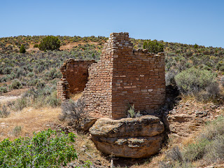
"Eroded Boulder House"


"Tower Point"


"Hovenweep Castle"


"Hovenweep House"


"Square Tower"


"Unit Type House"


Remains of a round tower in the canyon bottom


"Stronghold House"


We saw a few plants still blooming.


Cliff Rose


Spiny Hop Sage


Cactus


Lizard Head Pass

On April 30th, after over a month of staying close to our temporary "home'" in Cortez, Colorado (due to COVID-19), we decided to drive highway CO-145 up to 10,246 ft. Lizard Head Pass.


From Lizard Head Pass


Trout Lake


Ophir, Colorado


Monday, March 30, 2020

Valley of the Gods

After driving up to Muley Point, we headed down to the Valley of the Gods loop road.  This 17 mile unpaved road between UT-261 and US-163 passes through one of the most scenic areas in southeast Utah.


The Valley of the Gods Road wanders through an area south of Cedar Mesa where a series of canyons have eroded away most of the rock layers underlying the mesa, leaving behind some spectacular formations.


The Valley of the Gods B&B is close to the west end of the loop road.


One name for this formation is Balanced Rock.


Seen from another side, Balanced Rock is also called Lady in the Bathtub.


Some of the boulders look they could slide off at any time.


Does anyone else see Winnie the Pooh with his hand in the honey jar?


Setting Hen Butte


Castle Butte


An amazing landscape


The view about 2 miles north of the town of Mexican Hat


The town was named for this nearby rock formation.


Sunday, March 29, 2020

Moki Dugway and Muley Point

Another trip we took from Goulding's RV park was to Muley Point on the southern edge of Cedar Mesa, via the Moki Dugway.


At the beginning of the drive, we passed some classic Monument Valley formations.


The southern edge of Cedar Mesa in the distance


Approaching Cedar Mesa on Utah State Route 261,
Muley Point is on the far left.


To get to the top of Cedar Mesa, UT-261 climbs up the Moki Dugway. The Moki Dugway is a steep, switch-backed, unpaved road that was carved into the face of the cliff.

Looking down from near the top of the Moki Dugway


Highway UT-261 and the Valley of the Gods road far below


The sign at the top appears to have become a favorite for visitors adding stickers.


Near the top of the Moki Dugway, an unpaved road leaves UT-261 and leads 5 miles southwest to Muley Point.


Looking towards Monument Valley from Muley Point


Looking down into the Goosenecks of the San Juan River


Looking to the northwest along the San Juan River drainage


Scenery of the mesa top at Muley Point


An extremely scenic boondocking site!