Santa Ynez Valley

Santa Ynez Valley
Our Backyard

Friday, October 27, 2017

Yellowstone 2017

After heading west from South Dakota, we decided to drop down to visit Yellowstone.  We first spent a few days based in Gardiner, Montana, and then a few days based in West Yellowstone, Montana.


A badger near the Slough Creek Road


The trees in the Lamar Valley had pretty much lost their leaves.


Soda Butte at eastern end of the Lamar Valley


Interesting geology near Gardiner


Elk were still mowing the grass in Mammoth Village.


Bald Eagle near Swan Lake


Dusting of snow at Sheepeater Cliffs


A very empty Hayden Valley


Raven hoping for a handout


We got a couple inches of snow one night in Gardiner.


The snow didn't help our solar panel output.


Steam rising from Lower Geyser Basin


Panorama of the Midway Geyser Basin


Grand Prismatic Spring from the newly opened overlook


A coyote seen near Fountain Flat Drive


We often saw these creatures in the rivers.


A "small" crowd for the eruption of Old Faithful Geyser


Swan in the Firehole River


Wednesday, October 25, 2017

Spearfish Canyon South Dakota

After spending several days in Rapid City to establish South Dakota as our legal domicile, we spent a couple of nights in Spearfish, South Dakota, to visit Spearfish Canyon.  Spearfish Canyon is a narrow gorge carved by Spearfish Creek in the northern edge of the Black Hills.


Since it was well into October, there was some nice fall color.


And a very dry waterfall


Some type of red berry


The previous night had dusted the higher elevations with some fresh snow.


As we drove to higher elevation, we got into the snow.


Sunday, October 8, 2017

Sheffield New Brunswick Genealogy


We stopped in the Sheffield area along the St. John River in New Brunswick to do a little more genealogical research for Barbara.


Barbara found this plat map in the online New Brunswick archives that shows King's Land Grants that were issued in 1764.


Barbara's fourth great-grandfather, Samuel Upton, came from Massachusetts in 1764 and was awarded the plot numbered 27 on this map.  It was intriguing that the plots were 40 rods (220 yards) wide and up to 7 miles deep.  This insured that everyone had access to the river.


We happened to stay in a small campground in Sheffield associated with a country store and restaurant named Casey's.


While playing around with the map of land grants and some Google satellite imagery, we discovered that the campground just happened to sit right on the river end of Barbara's ancestor's land!


A short distance from Casey's store was this old house being reclaimed by the local vegetation.


Hopewell Rocks 2017

After Prince Edward Island, we headed down to Hopewell Cape, New Brunswick to re-visit another of our favorite places, Hopewell Rocks.  This is a wonderful location to really appreciate the tides of the Bay of Fundy.


The afternoon we arrived was the day of the solar eclipse.  While we didn't really expect to see anything, I did find that from our location the sun would be about 40% covered.  So I quickly assembled some very hi-tech gear to make my observations.  This involved a paper plate, a collapsible colander and my iPhone.


Later that afternoon we drove to nearby Hopewell Rocks at low tide, and then again the following morning at high tide.


The view from the top of the bluffs at the different tides


From another view point


From the top of the access stairs


The ocean floor below the bluffs at low tide


It was easy to see where the average high tides were in the erosion of this rock.


The access stairs at high tide


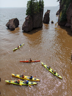
Kayak tours are led around the rocks during high tide.


Some flowers near the trails